The ability to read a map is one of those survival skills that increasingly is becoming lost in an ocean of technology. While map and compass navigation takes some knowledge and is a perishable skill, the act of reading and understanding a map is pretty simple.
Once you know what you are looking at, and how to use that information, you can start to recognize the relationship between map and the terrain.
For this article, I will be discussing topographic maps, but the basic principals outlined here can be used to read and navigate with virtually any map. This article is also specifically geared to the reading of a map and assumes that you are already proficient in the operation of a compass and GPS unit.
SKIP AHEAD
Key Information
There are a few key pieces of information that are listed on any topographic map. Magnetic declination, coordinate systems, map datum, legend, and scale are all pieces of information that you should take note of when reading a map.
Make sure to read our article on what kind of maps to keep with you…
Magnetic Declination
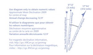
The location of the North on a map is not as simple as it would seem. There are three separate ‘Norths’ on a topographic map which are:
- True North, which is at the top of the map.
- Grid North, which is where the UTM grid lines point to
- Magnetic North, which is where your compass needle is pointing
Earth’s Magnetic North Pole is offset from True North and Grid North and this offset is known as magnetic declination.
Earth’s magnetic pole also moves over time and this movement has to be accounted for.
On a topographic map, there should be a magnetic declination diagram that will tell you the angle and direction of offset between True North, Grid North, and Magnetic North. In a lot of cases, the difference between True North and Grid North is too small to be adjusted for on a standard compass so they can be used interchangeably.
This diagram will show the degrees and direction of declination that existed during the year the map was printed. Using this information you can calculate what the current year’s declination is. Another option is to look up the magnetic declination for your map’s area using Google.
One important point of note is that the rate and direction in which declination changes that are written on your map is an estimate made at the time the map was printed. If your map is several decades old you will find that by figuring out this year’s declination mathematically the result will often be different than what the true magnetic declination is. It is important to have the most up to date information when adjusting your compass for your area’s magnetic declination.
If you have a compass that has adjustable declination you need to dial the current year’s declination into it so you can use a compass with your map. If your compass does not have adjustable declination then you will have to add or subtract the degree of declination every time you plot bearings.
Coordinate Systems
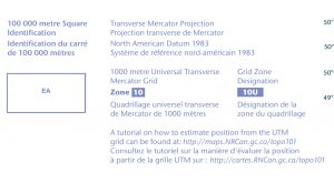
To identify a specific point on a map we use coordinates. These coordinates can be Latitude and Longitude or the Universal Transverse Mercator (UTM) system. There is also the Military Grid Reference System MGRS which uses the same grid lines as the UTM system with some minor differences.
Latitude and longitude is the coordinate system most of us have at least some familiarity with. Latitude and longitude coordinates are expressed as either Degree, Minutes, and Seconds (DMS) or Degree Decimals.
For example:
In degrees, minutes, and seconds.
- 37 Degrees 14’ 35” North Latitude by 115 Degrees 47’ 34” West Longitude.
Or in degree decimal.
- 37.243055 -115.793020
Latitude and Longitude coordinates have a drawback of not being quick or intuitive to plot or navigate by using a map and a compass. In a survival situation, it is faster, easier, and more precise to use either the UTM or the MGRS
UTM and MGRS Coordinates
UTM and MGRS coordinates use a grid of 1000m by 1000m squares to plot coordinates. This provides two distinct advantages over latitude and longitude. First is that plotting coordinates can be done very quickly using the UTM scale on the clear baseplate of a good compass. The second is that since these grid squares are 1000m by 1000m it is quick and easy to estimate distances on the map by counting grid squares.
An example of a UTM grid coordinate
- 11S 607051 E 4122518 N
And an MGRS coordinate
- 11S PB 07052 22518
The first two numbers and letters are the UTM grid zone. The world is divided into 60 grid zones each of these zones is divided again south to north into horizontal bands that are lettered from South to North with the letters C to X.
After the grid zone designator the first set of numbers is what is known as the Easting because we read the coordinates from west to east. The Easting grid lines are numbered by designating the center Easting line as 500,000m.
The second set of numbers is the Northing. These are the horizontal grid lines that are numbered acceding from the equator which is 0. To avoid negative numbers the southern hemisphere designated the equator as 10,000,000m North. The Northing of the UTM coordinate is essentially the distance in meters from the equator.
The MGRS divides the UTM grid zone into 100,000m by 100,000m squares which are designated with a two letter designator. Because of this, the MGRS designates each grid square with a pair of two-digit numbers instead of a distance in meters from the central meridian and the equator. This gives you less digits to interpret and makes plotting coordinates faster.
Map Datum
The coordinate system on a map has a defined point that it is based off. This point is called a datum and your map should have the datum used indicated on the map. Knowing your map’s datum is important because unless you program the correct datum into your GPS unit you will not be navigating with accurate coordinates. This also matters if you are trying to link up with other people by giving them a set of coordinates. If you do not also indicate your datum it is possible to end up several hundred meters apart.
Legend
The legend on a map will tell you what each symbol used on the map means. This information is important because a topographic map has a lot of lines, symbols, and grids which can be confusing without a legend to interpret them. Knowing how the different types of roads, waterways, buildings, or borders are drawn on the map is essential to read a map properly.
Scale
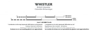
Topographic maps are drawn to scale which is represented by a representative fraction or a ratio such as 1/50,000 or 1:50,000. This means one unit of measurement on the map represents 50,000 of that unit of measurement on the ground. For example, a scale of 1:50,000 means 1 inch on the map equals 50,000 inches on the ground.
This also means that the higher the number (for example 1:250,000) the greater surface area the map covers but with far less detail, while the lower the number (for example 1:10,000) the map will cover less surface area but in greater detail.
A map should also have a scale drawn on the map that gives you a ruler that visually shows you what a mile or kilometer looks like on the map. You can use this to determine distances on the map by using a ruler, string, or some folded paper.
Reading the map
Once you know and understand all the key information that your topographic map is trying to show you it is time to start reading the map.
Orientating
Every time you pull your map out you need to orient it to the ground. What this means is that you hold the map so that the top of the map points to True North.
How you do this is you take your compass, which should have adjustable declination, and the correct declination dialed in, and line up the edge of the compass with the edge of the map.
Make sure that the bezel on the compass is dialed to point North. Rotate the map until the needle of the compass sits inside the declination arrow (which is known as red in the bed). Once you do this the map is oriented to the ground which makes navigation with it simpler.
Understanding contour lines
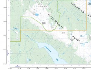
One of the key features of a topographic map is the contour lines which are a way to visually demonstrate changes in terrain. A contour line is brown and represents a line of continuous elevation above sea level. For example, if a contour line says it is 500 meters above sea level then any point along that line will be 500 meters in elevation. A topographic map will also have something referred to as a contour interval which is the difference in elevation between the contour lines.
Since contour lines are representing elevation, the closer the lines are together the steeper the terrain, and the more spaced out they are the more gradual the slope.
Some contour lines are drawn thicker and have an elevation written into them. These are known as index lines and are there to inform you what the elevation of that contour line is so you can determine the elevation of the adjacent lines using the contour interval as a reference.
Plotting Coordinates
Latitude and longitude
Each corner of the map will have its latitude and longitude indicated and the edges of the map area are divided up into minutes of latitude and longitude. To plot latitude and longitude coordinate set, you’ll need to project the marks along the edge of the map to the point you wish to plot.
Plotting latitude and longitude is not at all efficient and takes time, practice, and skill to do accurately which I will not cover here because a better system, especially for survival, is the UTM or MGRS.
Plotting a UTM or MGRS Coordinate
We know how a UTM and MGRS coordinates break down but how do we plot them on a map?
The process is the same for both UTM and MGRS coordinates.
- Find the grid square that the point you want to plot is located in.
- Starting with the Easting, determine what the number of the Easting line for this grid square is.
- Then determine the Northing grid line number.
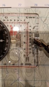
- Using a UTM scale on a compass or roamer plot how many meters the point is from Easting and then the Northing.
- This gives you your full grid coordinate.
An easy way to remember how to plot coordinates is the phrase ‘in the door up the stairs’. If you picture the map as a house you would walk left to right (West to East) to go ‘through the door’, then go up (North) which would be the ‘up the stairs’.
Terrain Association
As you use a map put in the wilderness you’ll begin to mentally associate the contour lines on the map with the terrain in real life. As you start to form this ability you can start to forgo using a compass while navigating by using the technique of terrain association.
It is best if you have a good vantage point with a view of the surrounding terrain. As you hold the map look up and see if you can match terrain features that you can see in front of you with features on the map. You can look for peaks, valleys, saddles, rivers, ridgelines, etc, and then find them on your map. You can then use this information to deduce your location and to orient the map to the ground.
When you know where you are you can plot a route that follows terrain features instead of using compass bearings or a GPS.
For example, you could follow rivers, valleys, ridgelines, roads, powerlines, etc to move towards your objective instead of dead reckoning cross country.
Terrain association works well too when you are on the move and can keep track of several landmarks to assist you in keeping yourself on the right path.
Wrap Up
This has been a very basic break down on how to read a map in a survival situation. The topic of land navigation is very broad and entire books have been written on the subject. Before heading afield make sure that your understanding and skill in land navigation are up to date and well practised.


